Cities In The Mekong Delta

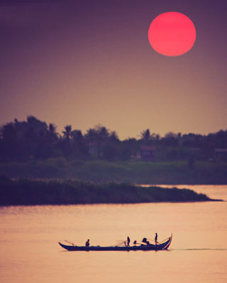
The Mekong Delta, as a region, lies immediately to the west of Ho Chi Minh City, roughly forming a triangle stretching from Mỹ Tho in the east to Châu Đốc and Hà Tiên in the northwest, down to Cà Mau and the South China Sea at the southernmost tip of Vietnam, and including the island of Phú Quốc.
The Mekong Delta, as a region, lies immediately to the west of Ho Chi Minh City, roughly forming a triangle stretching from Mỹ Tho in the east to Châu Đốc and Hà Tiên in the northwest, down to Cà Mau and the South China Sea at the southernmost tip of Vietnam, and including the island of Phú Quốc.
Bac Lieu
Baclieu province locate coastal East-sea in the South of Vietnam, in Camau peninsula the East-Southeast to the East-sea, the West-Southwest neighbouring Camau province, the North neighbouring Haugiang - Kiengiang province, The East - Northeast neighbouring Soctrang province, the area of natural land 258,247.
The town has a few elegant but forlorn French colonial buildings, like the impressive Fop House (now used as a community sports centre), but not much else.
Farming is a difficult occupation here because of saltwater intrusion, which mean that the town has remained fairly poor. The province is, however, known for its healths longan orchards. In addition to this, the enterprising locals eke out a living trom fishing, oyster collection and shrimp farming, as well as salt production (obtained from evaporating saltwater ponds that form immense salt flats).
For the Vietnamese people, Bat Lieu's main claim to fame is the grave site of Can Van Lau (1892-1976), famed composer of 'Dai Coa Hoai Long' ('Night Song of the Missing Husband').
Most foreigners give the tomb a miss and instead use Bac Lieu as a springboard to reach the outstanding bird sanctuary out of town. If you're keen on seeing it, head out on Cao Van Lau st. towards the bird sanctuary lor about 1km. turn right and follow the dirt road for 150m to the grave.
Tra Vinh
About 300, 000 ethnic Khmer live in Tra Vinh province. At first glance, they might seem to be an invisible minority since they all speak fluent Vietnamese and there's nothing outwardly distinguishing about their clothing or lifestyle. However, digging a little deeper quickly reveals that Khmer culture is alive and well in this part of Vietnam, There are over 140 Khmer pagodas in Tra Vinh province, compared with 50 Vietnamese and five Chinese pagodas. The pagodas have schools to teach the Khmer language most of the local in Tra Vinh can read and write Khmer at least as well as Vietnamese.
Vietnam's Khmer minority are almost all followers of Theravada Buddhism. If you've visited monasteries in Cambodia, you may have observed that Khmer monks are not involved in growing food and rely on donations from the strictly religious locals. Here in Tra Vinh, Vietnamese guides will proudly point out the monks' rice harvest as one of the accomplishments of liberation. To the Vietnamese government, non working monks were parasiles. The Khmer don'l necessarily see it the same way and continue to donate funds to the monasteries surreptitiously.
Between the ages of 15 and 20, mosl boys sel aside a lew months or years to live as monks (they decide themselves on the length of service). Khmer monks are allowed to eat meal, although they can not kill animals.
There is also a small but active Chinese community in Tra Vinh, one of the few remaining in the Mekong Delia region.
Ben Tre
Ben Tre is situated in Mekong Delta. It shares its border with Tien Giang in the north, Vinh Long in the west and south - west, and Tra Vinh in the south. It has 60km seashore. The four main rivers are Tien Giang, Ba Lai, Ham Luong, and Co Chien. They create Bao, Minh, and An Hoa islets.The topography is flat with sand dunes and fields. Though rivers surrounding the province, water transportation is very available.
Having complex network of rivers and canals, Ben Tre has advantage to develop ecotourism with many green fruit gardens. Ben Tre is the granary of Mekong Delta. There are agriculture productions such as rice, corn, pineapple, custard-apple, star apple, durian, mango, longan, and many more. Industrial trees are tobacco, sugar-cane, and cotton. Especially, Ben Tre is homeland of coconut. It is known with Ben Tre coconut candy, My Long Cai Mon flower and ornamental plant.
Ben Tre is well known as poet Nguyen Dinh Chieu's motherland. Other popular places are My Hoa Bird Reserve, Con Phung (Hillock of the Coconut Religion), Vam Ho Bird Sanctuary, Vien Minh Pagoda.
Ben Tre is a good place lor boat trips and, unlike My Tho, Vinh Long and Can Tho, the People's Committee doesn't have a monopoly on the boat tour business so prices have remained low.
Ben Tre is famous for coconut candy (keo dua). Many local women work in small factories making coconut sweets, spending their days boiling large cauldrons of sticky mixture, before rolling it out and cutting sections off into squares and wrapping them into paper for sale.
My Tho
In order to visit floating markets, however, you'll need to continue on to Can Tho.
Being located so close to booming HCMC, one would expect My Tho to have profited handsomely from the country's economic reforms. Sadly, this is not the case - My Tho is one of the poorest cities in the Mekong Delta, though it is said tc have the richest government and one of the strictest police forces.
My Tho was founded in the 1680s by Chinese refugees fleeing Taiwan for political reasons. The Chinese have virtually all gone, now, having been driven out in the late 1970s when their property was seized by the government. The economy - or what's left of it - is based on tourism, fishing and the cultivation of rice, coconuts, bananas, mangoes, longans and citrus fruit.
Chau Doc
The town is located on the right bank of Hau Giang, 5 km away from Sam mountain, the highest point on the Delta. This mountain gets the name from its shape of a king crab, which is "sam" in vietnamese. It is a sacred mountain for many locals since it is dotted with pagodas and temples. Chau Doc is very famous for "ma('m", a type of fermented fish used regularly as food ingredients or garnishes.
With a population of 85, 000, Chau Doc is a bustling city with heavy trade of illegal goods crossing the cambodian border. From smugglers on bicycle carrying cartons of cigarettes on their back to boats loaded with VCR and TV sets to new cars originating from Thailand, it seems like anything is fair game in the wild west of Vietnam.
Sa Dec
n the 1700s, the area was exchanged with the Vietnamese for military aid. Since then many Vietnamese have settled in this area and effectively annexed this whole area. The Chan Lap were subsequently wiped out and assimilated by the Vietnamese and today the population consists mostly people of Chinese, Khmer, Cham and Thai origin.
Sa Dec has become less and less prosperous ever since Cao Lanh was named capital of the province to reward communist cadres from the area after the war ended. New constructions and developments are now occuring in Cao Lanh, the commercial hub of the region.
Long Xuyen
Many of the produce grown in the vicinity are shipped here before being transported elsewhere. With a population over 100, 000 people, it has a significant number of catholics as the city boasts the largest Catholic church in the region, seating up to 1000 people.
Long Xuyen is a big town with slow pace living. Unlike its motorized cousin in Can Tho, "Xe Loi" here is pulled by bicycle. 40 km from Long Xuyen is the hilly area of Ba The where the ruins of the Oc Eo civilization dating back to the first century A.D. were discovered. The Oc Eo civilization reached its height in the 5th century and was part of the foundation of the Phu Nam (Funam) kingdom.
Can Tho
Since the beginning, Can Tho was already given the title Tay Do or Western Capital. It is also the meeting point of the various waterways of the Mekong Delta. Today, it has become an industrious city with big bottling companies and fish sauce factories. It is is home to 220, 000 inhabitants.
Can Tho is a busy port capable of accomodating large ships from neighbouring countries. Hau Giang or Hau River is the main channel that passes through Can Tho. The land mass surrounding the river was developed very early so the population in this area is probably the largest in all of the Delta region. The land here is said to be the most fertile because of the deposits from the various branches of the river.
Ben Ninh Kieu is probably the most well known landmark in Can Tho. The port lies on Hau Giang and crosses the city of Can Tho. The city opens to the water front where port Ninh Kieu is the focal point of all activities on the river. Frequent ferries carry passengers to Xom Chai island, just a short distance away and a beautiful sight at sunset.


